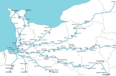
Norman tracks / map

The way from ROUEN
The Way of Rouen 1 on Google Map
The Way of Rouen 2 on Google Map
For pilgrims and travellers arriving from Picardy or Flanders, Rouen the old capital of the former duchy of Normandy, was a bustling city.
From the great Cathedral to the fine timber-framed town houses, many monuments remain to remind us of the city’s former great wealth and influence.
There were several possibilities when planning a journey from here to Mont St Michel. The path taken by today’s pilgrim follows the main medieval routes. After passing through the Roumare Forest and crossing the River Seine at La Bouille, the path goes through the forest of Montfort which surrounds the Abbey of Le Bec Hellouin. Thence it follows the valleys first of the Risle and then of the Charentonne rivers. At Le Pont de Vie near Vimoutiers the route was already well known in the eleventh century : contemporary documents refer to "the path leading to Mont Saint Michel".
Arriving at Falaise, an important stage on the eleventh century route, the pilgrim would have been impressed by the imposing fortified castle of Duke Robert the Magnficent. Vire was a fortified town in the twelfth century, associated with Henry I. The inhabitants of Vire have always been faithful adherents of the archangel Michael.
Avranches is the last stop on our route, and you will find here the Scriptorium Museum where you can see the manuscripts illustrated by the monks of Mont St Michel, the treasure of St Gervais, many ancient houses, and don’t forget to visit the botanical garden where there are superb views of the bay encircling the rock of Mont St Michel itself.
This route takes us through contrasting Norman scenes, through cool leafy forests to fine medieval cities.
STAGES
Total : 360 km – 16 stages
TO GUIDE YOU
Our guidebook : « Le chemin de Rouen au Mont-Saint-Michel »
It contains accounts by pilgrims of their journey and numerous illustrations showing the historic sites you will discover. Pratical index cards showing maps.
To order
Accomodations
GPX files for GPS :
 - Rouen - Canteleu
 - Canteleu Barneville
 - Barneville - Montfort
 - Montfort -Brionne
 - Brionne - Bernay
 - Bernay - Orbec
 - Orbec - Vimoutiers
 - Vimoutiers- Trun
 - Falaise - Pont-d’Ouilly
 - Pont-d’Ouilly - Vassy
 - Vassy - Vire
 - Vire - Saint-Pois
 - St Pois - Petit- Celland
 - Petit-Celland Avranches
 - Avranches - Genêts
|